Apple Maps begins blurring NASA, Space Force, and Air Force bases
Apple Maps updated its satellite imagery layers to blur sensitive US Space Force launch complexes, NASA facilities, and nuclear bomber runways nationwide.
By Dillip Chowdary • Oct 31, 2026 • Source: 9to5Mac
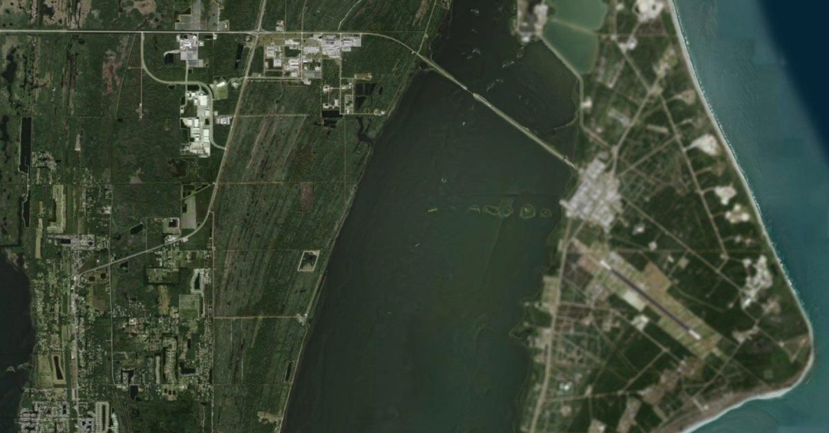
Apple updated its satellite imagery layers across Apple Maps to blur key military, civil spaceflight, and national security installations, according to 9to5Mac's report. The unannounced modification masks overhead satellite views of active rocket pads and runways across multiple states while leaving rival platforms like Google Maps entirely unblurred. The adjustments prevent public phone users from viewing fighter jets parked on tarmacs or rockets staged across military pads, establishing a strict visual security filter over specific federal flight corridors.
This breakdown examines the installations affected by the visual filtering rollout, the specific perimeter boundaries obscured across defense locations, and what field personnel should anticipate regarding consumer navigation interfaces. The analysis details how base access and facility visibility diverge between civilian research wings and active defense wings across several military branches.
What Apple Maps begins blurring NASA shipped
Apple deployed satellite obfuscation layers across multiple defense installations and space launch complexes across the United States. The initial rollout obscures active national defense spaces, including Cape Canaveral Space Force Station and Patrick Space Force Base in Florida, alongside Vandenberg Space Force Base in California. Critical bomber installations received direct visual masking, notably Whiteman Air Force Base in Missouri, which houses the fleet of nuclear-capable B-2 stealth bombers, and Ellsworth Air Force Base in South Dakota, which hosts B-1B bombers. Highly classified government test facilities, including Groom Lake, commonly known as Area 51, and Los Alamos National Laboratory in New Mexico, are also obscured.
The filtering also reaches civilian aerospace centers managed by NASA, applying visual blurs across sensitive flight testing infrastructure. Stennis Space Center in Mississippi and the runway complex at Wallops Flight Facility in Virginia are masked from public satellite examination. At Wallops Flight Facility, the visual blur targets the primary civil airfield directly, whereas the adjacent coastal orbital rocket launch pads remain visible on the standard imagery layer. Apple executed the satellite imagery change directly within consumer-facing tiles without publishing a formal press bulletin or release changelog detailing the geographic criteria.
What changed for builders in Apple Maps begins blurring NASA
Defense analysts and geospatial software builders now encounter asymmetric tile masking across federal aerospace complexes. Active defense launch infrastructure at Cape Canaveral Space Force Station is masked, while historic civilian launch complexes LC-39A and LC-39B at the adjacent Kennedy Space Center remain clear and unobstructed. A similar division appears between strategic bomber facilities, where Whiteman and Ellsworth Air Force Bases feature blurred aerial assets, while Dyess Air Force Base and Barksdale Air Force Base, which houses seventy-four-year-old B-52 bombers, remain fully rendered in high resolution.
| Facility Name | Branch or Operator | Prior View Status | Updated Tile Status |
|---|---|---|---|
| Whiteman Air Force Base | US Air Force | High-resolution satellite | Blurred imagery |
| Ellsworth Air Force Base | US Air Force | High-resolution satellite | Blurred imagery |
| Cape Canaveral SFS | US Space Force | High-resolution satellite | Blurred imagery |
| Vandenberg SFB | US Space Force | High-resolution satellite | Blurred imagery |
| Wallops Airfield | NASA | High-resolution satellite | Blurred imagery |
| Groom Lake (Area 51) | US Air Force | High-resolution satellite | Blurred imagery |
| Los Alamos National Lab | Department of Energy | High-resolution satellite | Blurred imagery |
| Google Maps Counterparts | Commercial Service | High-resolution satellite | Unblurred imagery |
Civilian developers reviewing naval installations observe that major naval harbors remain untouched by the visual filtering filter. Naval Station Norfolk, Naval Station Great Lakes, and Pearl Harbor continue to render transparent satellite perspectives across harbors and support facilities. Local Air National Guard wings, including installations across Wisconsin, similarly retain raw photographic fidelity without obscuration filters. The masking policy focuses strictly on missile tracking, orbital launches, nuclear strike complexes, and advanced research facilities.
How to install or upgrade Apple Maps begins blurring NASA
Because Apple serves map imagery dynamically through its content delivery network, end users receive updated satellite tiles automatically across iOS, iPadOS, and macOS without requiring local client upgrades. Developers operating automated toolchains, test scripts, or command-line wrappers that pull map assets or inspect client configurations can maintain local tooling using standard package updates.
Advertisement
Tech Pulse Daily
Get tomorrow's pulse first
Join engineers who read Tech Pulse before stand-up. Free, weekday mornings.
npm install -g @anthropic-ai/claude-codeTo configure developer environments or inspect automated mapping agents against specific model targets, teams can switch runtime definitions within interactive terminal workflows.
/model claude-fable-5-1Developers testing persistent platform scripts can run designated models directly via command line arguments to verify image capture interfaces and satellite asset rendering.
claude --model fableTo ensure continuous execution across headless verification runs, teams can establish the default runtime within global CLI preferences, ensuring consistency during integration testing on workstation profiles.
claude config set --global default_model claude-fable-5-1Gotchas and compatibility in Apple Maps begins blurring NASA
The deployment introduces operational ambiguities for civilian personnel, commercial contractors, and military staff commuting to restricted facilities. Because Apple applied visual blurring to overhead imagery tiles without clarifying routing vector behavior, questions remain regarding how turn-by-turn guidance and in-car systems function across restricted gates. On-base personnel driving vehicles linked through Apple CarPlay must verify whether navigation directions continue across covered surface streets or whether routing halts at base perimeter boundaries.
A significant compatibility distinction remains the divergence between competing mapping services across standard mobile devices. Google Maps maintains clear, high-resolution satellite imagery across the exact installations Apple blurred, including Cape Canaveral Space Force Station, Vandenberg Space Force Base, and Whiteman Air Force Base. Field teams relying on uniform overhead views across multi-platform device deployments will encounter inconsistent visual data, requiring navigation protocols to account for platform-specific tile redactions.
What to watch after Apple Maps begins blurring NASA
Geospatial teams and defense observers are monitoring whether Apple expands visual redactions to cover additional Department of Defense installations nationwide. Unblurred bomber hubs like Dyess Air Force Base and Barksdale Air Force Base remain visible, indicating that additional passes may target remaining strategic command hubs in subsequent tile updates. Observers are also monitoring whether NASA installations currently displaying partial visibility, such as the active launch pads at Wallops Flight Facility, will eventually face full perimeter redaction.
The broader mapping ecosystem will indicate whether competing commercial satellite providers follow Apple's lead in obscuring active defense infrastructure. If Google Maps or private satellite vendors retain unblurred public imagery of US Space Force complexes and nuclear bomber runways, government agencies may issue formal commercial guidelines governing resolution limits. The ongoing expansion will demonstrate whether visual filtering becomes a permanent standard across consumer map applications.
Developer Action Items
- ☐ Diff the official changelog for Google / Apple before you bump — APIs, defaults, and removed flags only.
- ☐ Install through the vendor's documented channel in staging; keep a one-command rollback and time-box the canary.
- ☐ Grep your repo for old flag names, lockfile pins, and plugin versions that the notes mark as breaking.
- ☐ Prefer the first patch cut over the day-zero tag unless you have a reason to be on the leading edge.
- ☐ If 9to5Mac did not name a region, plan, or SKU, screenshot the official availability line before you promise it to users.
Apple Maps begins blurring NASA FAQ
Which Air Force bomber bases are blurred on Apple Maps?
Whiteman Air Force Base in Missouri, home to the B-2 stealth bomber, and Ellsworth Air Force Base in South Dakota, home to the B-1B bomber, are blurred. Dyess Air Force Base and Barksdale Air Force Base remain unblurred.
Are NASA launch pads at Kennedy Space Center obscured?
Historic launch pads LC-39A and LC-39B at Kennedy Space Center are not blurred, though NASA's airfield at Wallops Flight Facility and Stennis Space Center are blurred.
Has Google Maps also blurred these military and space bases?
Google Maps has not blurred these military and space installations, leaving high-resolution imagery visible across bases where Apple Maps applied visual masking.
Sources

Author
Dillip Chowdary
Writes Tech Bytes coverage of AI, engineering, and the tools that actually ship. Editor of Tech Pulse Daily.
Related on Tech Bytes
Advertisement