Claude skill that turns any two places into a pixel-art fly-through
Jon Wheatley launched Pixel Path, an open-source Claude Code skill that turns geographic routes into interactive pseudo-3D pixel-art road journeys.
By Dillip Chowdary • Nov 07, 2026 • Source: github.com
Developer Jon Wheatley released Pixel Path, an open-source Claude Code skill that turns any two geographic locations into an interactive pixel-art fly-through along real roads, as detailed in github.com's report. The tool routes a journey using OpenStreetMap coordinates, extracts real building footprints, ground cover, landmarks, and terrain elevation grids, and generates regional scenery graphics using RetroDiffusion. Once processed, the skill provides a self-contained web directory with an interactive page that lets users navigate the drive forwards, backwards, or at varied speeds.
This technical breakdown examines how the generation pipeline automates map data extraction, budget estimation, sprite cleanup, and visual verification. The tool serves developers creating retro driving or idle games, digital creators producing travel recaps and video stream backgrounds, historians animating routes, and engineers studying pseudo-3D road rendering. Operating under the MIT license with Open Database License map requirements, the project integrates Claude Code CLI workflows directly with geospatial APIs and machine-learning art generators.
Claude skill that turns any two places: what actually changed
Pixel Path replaces manual sprite placement and procedural guesswork by tying a classic pseudo-3D road projection directly to authentic geographic databases. Instead of creating fictional racing tracks, the skill accepts natural prompts such as asking Claude for a route from Bath to Bristol, then queries OpenStreetMap, OSRM routing, Nominatim geocoding, AWS Terrain Tiles, and Wikidata. Every building facing the roadway is placed on its surveyed footprint line, with height and category attributes determining facade geometry.
The engine structures frontage so that long continuous street lots become diverse rows of buildings while closing cracks under 3 meters. A secondary row of structures renders behind gaps, town squares, and car parks, while tall buildings form an accurate skyline. Fields, forests, parking lots, and sidewalks render from land-use classifications per pixel. Exact signage names, distances, railway crossings, and brown landmark signs are generated entirely through programmatic canvas code rather than visual diffusion models.
Claude skill that turns any two places: how it works
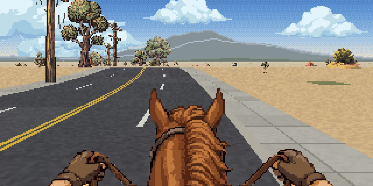
The workflow runs through Claude Code as an installed marketplace plugin or a manual file placed in the local skills directory. Baking takes between 20 and 60 seconds per 10 kilometers over active network connections. Elevation curves derive from Mapzen and Tilezen terrain data hosted on AWS Open Data, processing SRTM, GMTED2010, ETOPO1, and NED datasets over a 61 by 61 kilometer grid that factors in the Earth's curvature. Users navigate the resulting page using keyboard arrow keys, touch dragging, or mouse scrolling, with space pausing movement, the M key displaying a mini-map, and the I key printing location data.
Before generating paid art, the tool prints an upfront cost estimate based on distinct architectural regions. Scenery art costs $0.18 per image using RetroDiffusion's rd_prodefault model as of October 2026. A placeholder tier costs zero dollars with code-drawn stand-ins, a sparse tier generates 4 images per region for $0.72, a moderate tier produces about 14 images plus 4 landmarks for $3.24, and a detailed tier generates 26 images plus 10 landmarks for $6.48. Users must factor in approximately 25 percent additional budget for automated re-rolls when diffusion outputs arrive misaligned.
Advertisement
Tech Pulse Daily
Get tomorrow's pulse first
Join engineers who read Tech Pulse before stand-up. Free, weekday mornings.
Claude skill that turns any two places: why it matters
Procedural world building traditionally requires either abstract fictional tiles or expensive modern three-dimensional photogrammetry. Pixel Path provides an automated bridge that translates open spatial cartography into lightweight, nostalgia-driven game environments. Because the output packages into a plain static folder containing an index file, developers can run complete interactive environments through basic local web servers without complex client runtimes or external node dependencies during playback.
The system enforces rigorous automated quality control before marking a route finished. Using Node 20 with Playwright and headless Chromium, the skill evaluates the entire scene layout, drops graphics where backdrops fail to clear, and initiates visual sweeps every 75 meters of built-up roadway. By masking buildings against a magenta sky background across multiple camera angles, the tool detects transparent gaps or broken street walls, passing the 20 worst test frames back to Claude Code to iterate and re-roll defective assets autonomously.
Claude skill that turns any two places: who is affected
Game designers gain a rapid prototyping framework to convert real-world commutes, marathon routes, or delivery rounds into playable levels for endless-runners, racing games, or idle simulations. Content creators obtain a quick mechanism to generate animated journey recaps, video introductions, and looping backgrounds without drawing pixel scenes frame by frame. Programmers and students gain an educational reference implementation demonstrating classic pseudo-3D road math alongside real-world geospatial data pipelines.
Users must manage specific operating requirements, including Node 18 or newer for basic compilation and a funded RetroDiffusion account for custom imagery. The API token must be set through terminal environment variables or the macOS Keychain, as the skill never asks for or logs credentials in chat. Users redistributing output data must also comply with OpenStreetMap's Open Database License, maintaining visible credit attribution for the underlying derived database files and map contributors.
Claude skill that turns any two places: what to watch
Performance and stability depend heavily on public geospatial infrastructure, particularly the Overpass API, which can time out under heavy server loads during complex queries. Where OpenStreetMap coverage lacks surveyed footprints, the skill falls back to heuristic approximations based on zone usage, inferring building dimensions from general property designations. Open urban areas such as wide intersections and central plazas reflect their genuine open layout, which can occasionally display as broad paved spaces on screen.
Visual fidelity remains constrained by 2.5D projection limitations. Regional art packs share building graphics across towns within the same zone, requiring users to split extensive routes into multiple defined segments to maintain visual variety. Furthermore, regional landmarks are rendered as flat facing illustrations rather than rotating three-dimensional models, requiring descriptive prompts for the diffusion generator. Watch for how future iterations handle high-density metro baking speeds and expand multi-angle perspective rendering for intersecting roads.
Developer Action Items
- ☐ Diff the official changelog for Claude / AWS / GitHub 0.18 before you bump — APIs, defaults, and removed flags only.
- ☐ Install through the vendor's documented channel in staging; keep a one-command rollback and time-box the canary.
- ☐ Grep your repo for old flag names, lockfile pins, and plugin versions that the notes mark as breaking.
- ☐ Prefer the first patch cut over the day-zero tag unless you have a reason to be on the leading edge.
- ☐ If HN Claude/Codex/Fable did not name a region, plan, or SKU, screenshot the official availability line before you promise it to users.
Claude skill that turns any two places FAQ
How much does it cost to generate art for a route in Pixel Path?
Art generation costs depend on the chosen detail tier and region count, ranging from free for code-drawn placeholders to $0.72 for sparse, $3.24 for moderate, and $6.48 for detailed regions at $0.18 per RetroDiffusion image. Users should budget an additional 25 percent for automated re-rolls.
What software dependencies are required to run Pixel Path?
Running the skill requires Node 18 or newer without extra npm packages to build routes, alongside a RetroDiffusion API key for custom art. Running the optional automated screenshot self-check requires Node 20 or newer with Playwright and Chromium installed.
How does Pixel Path verify the visual quality of generated routes?
The tool uses Playwright and Chromium to sweep every 75 meters of road, painting the sky magenta to detect gaps or sky visible through buildings across three camera angles. Claude inspects the 20 worst frames and automatically re-rolls defective assets until the sweep passes.
Sources

Author
Dillip Chowdary
Writes Tech Bytes coverage of AI, engineering, and the tools that actually ship. Editor of Tech Pulse Daily.
Related on Tech Bytes
Advertisement